GREAT BRITAIN
Unit 1
This unit will describe the land, physical features, and climate of the United Kingdom of Great Britain, and the interaction between these natural features and people who live in the country and will cover the following items:
· the country’s name and area
· physical geography
· the four regions of the UK
· major lakes and river systems
· demography of the UK
· cities of the UK
· climate and biodiversity

The full name of the country is the United Kingdom of Great Britain and Northern Ireland. Although most people just refer to it as the United Kingdom or the UK. Great Britain is very often, but incorrectly, used as a synonym for the sovereign state properly known as the United Kingdom of Great Britain and Northern Ireland or the UK for short. If you look at the full name of the UK you will see that the UK includes Great Britain and Northern Ireland. Great Britain (= GB for short) is a political term which describes the combination of England, Scotland, and Wales, the three nations which together include all the land on the island. It is also a geographical term referring to the island on which the greater parts of England, Wales and Scotland are situated.
Sometimes people use the shorten name Britain instead of Great Britain, to mean the same thing, but really Britain only refers to England and Wales.
The name Britain goes back to Roman times when they called England and Wales "Britannia" (or "Britannia Major", to distinguish from "Britannia Minor", i.e. Brittany in France). The Roman province of Britannia only covered the areas of modern England and Wales. The area of modern Scotland was never finally conquered.
British Isles means GB plus all the other islands including Ireland (=Republic of Ireland).
Physical geography: The United Kingdom is situated on an archipelago known as the British Isles. The British Isles consist of two large islands, Great Britain and Ireland, and a great number of surrounding island groups of the Hebrides, the Shetlands, the Orkneys, the Isle of Man and the Isle of Wight. Their total area is over 314 000 sq. km. The United Kingdom is located off the northern coast of France, and west of Sweden and Denmark, between the North Sea and the North Atlantic Ocean. With an area of 243,610 sq km (94,058 square miles) the United Kingdom itself is not quite half the size of Spain, or slightly smaller than the U.S. state of Oregon. Great Britain has a coastline of 7,723 miles (12,429 m).
The North Channel, the Irish Sea, the St George's Channel and the Celtic Sea separate the island of Great Britain from the island of Ireland to its west. Northern Ireland occupies one third of the island of Ireland. It borders on the Irish Republic in the south. The western coast of Great Britain is washed by the Atlantic Ocean and the Irish Sea.
The British Isles are washed by the North Sea and the English Channel, which narrows to 34 kilometers (21 mi) at the Straits of Dover. It stretches over about ten degrees of latitude on its longer, north-south axis, and occupies an area of 209,331 km² (80,823 sq mi), excluding all the smaller surrounding islands of the archipelago. The island is physically connected with continental Europe via the Channel Tunnel, the longest undersea rail tunnel in the world which was completed in 1993.
The island of Great Britain consists of three main parts: England (the southern and middle part of the island), Wales (a mountainous peninsula in the West) and Scotland (the northern part of the island).Great Britain is the ninth largest island in the world and the largest in Europe.
Geographically, the island is marked by low, rolling countryside in the east and south, while hills and mountains predominate in the western and northern regions. It is surrounded by over 1,000 smaller islands and islets. The greatest distance between two points is 968 km (601.5 miles) (between Land's End, Cornwall and John O'Groats, Caithness), or 1,349 km (838 miles) using the national road network.
Interesting to know: The English Channel is thought to have been created between 450,000 and 180,000 years ago by two catastrophic glacial lake outburst floods caused by the breaching of the Weald-Artois Anticline, a ridge which held back a large proglacial lake, now submerged under the North Sea.
Around 10,000 years ago, during the Devensian glaciation with its lower sea level, Great Britain was not an island, but an upland region of continental northwestern Europe, lying partially underneath the Eurasian ice sheet. The sea level was about 120 meters (390 ft) lower than today, and the bed of the North Sea was dry and acted as a land bridge, now known as Doggerland, to the Continent. It is generally thought that as sea levels gradually rose after the end of the last glacial period of the current ice age, Doggerland became submerged beneath the North Sea, cutting off what was previously the British peninsula from the European mainland by around 6500 BC.
The official language in the UK is English, recognized regional languages are Scottish, Scottish Gaelic, Welsh, Irish, and Cornish.
 Border Countries: Ireland, since 1994 the Channel Tunnel beneath the English Channel links the UK with France. Britain shares maritime borders with Belgium, Denmark, France, Germany, Netherlands, Norway, and the Faroe Islands (Denmark), Highland Boundary Fault from the Scottish Lowlands.
Great Britain is not very rich in mineral resources; it has some deposits of coal and iron ore and vast deposits of oil and gas that were discovered in the North Sea.
Great Britain is home to the United Kingdom (the UK) which is made up of four different regions that are not independent nations. These regions are England, Wales, Scotland and Northern Ireland.
Next come some facts about the UK's four regions.
England
England is the largest of the four geographical regions making up the United Kingdom. It occupies the central and southern two-thirds of the island of Great Britain. It is bordered by Scotland to the north and Wales to the west and it has coastlines along the Celtic, North and Irish Seas and the English Channel. Its total land area is 50,346 square miles (130,395 sq km) and a population of 51,446,000 people (2008 estimate).
The longest river entirely in England is the Thames, with 346 km (215 mi). It runs through London. The northern part of England is dominated by the Pennines, a low-rising mountain range, considered to be one of the most scenic areas in the United Kingdom. South of the Pennines are the English Lowlands which consists of rolling hills.
The capital and largest city of England (and the UK) is London. The Royal Greenwich Observatory, situated in South East London, is the defining point of the Prime Meridian (Longitude 0°).
England is separated from continental Europe 21 mile (34 km) by the English Channel but they are connected by the undersea Channel Tunnel.
Scotland
Scotland is the second largest of the four regions making up the UK. It is located on the northern part of Great Britain and it borders England to the south and has coastlines along the North Sea, Atlantic Ocean, North Channel and Irish Sea. Its area is 30,414 square miles (78,772 sq km) and it has a population of 5,194,000 (2009 estimate). Scotland's area also includes almost 800 offshore islands. The capital of Scotland is Edinburgh but the largest city is Glasgow.
The topography of Scotland is varied and its northern portions have high mountain ranges, while the central portion consists of lowlands and the south has gently rolling hills and uplands. Despite its latitude, the climate of Scotland is temperate because of the Gulf Stream.
The highest elevation in Britain is Ben Nevis 1,344 m (4,409 ft), located in the Grampian mountain range, one of the three major mountain ranges in the Scottish Highlands. The sparsely populated Highlands at the northern end of Great Britain island are one of two main historical regions in Scotland. Scotland is divided into three distinct geographical areas: 1. the mountainous Highlands, 2. the relatively low-lying Central plain (Central Belt), the area with the highest population because most of the major cities of Scotland are located there, and 3. the southernmost part in Scotland, the Southern Uplands, a mainly agricultural region with hills and valleys.
Wales
Wales is a region of the United Kingdom that is bordered by England to the east and the Atlantic Ocean and Irish Sea to the west. It has an area of 8,022 square miles (20,779 sq km) and a population of 2,999,300 people (2009 estimate). The capital and largest city of Wales is Cardiff with a metropolitan population of 1,445,500 (2009 estimate). Wales has a coastline of 746 miles (1,200 km) which includes the coastlines of its many offshore islands. The largest of these is Anglesey in the Irish Sea.
Wales is generally a mountainous country, particularly in the north and central regions. Its highest mountain is Snowdon with 1,085 m (3,560 ft). Wales has a temperate, maritime climate and it is one of the wettest regions in Europe. Winters in Wales are mild and summers are warm.
Northern Ireland
Northern Ireland is a region of the United Kingdom that is located on the northern part of the island of Ireland. It borders the Republic of Ireland to the south and west and has coastlines along the Atlantic Ocean, North Channel and Irish Sea. Northern Ireland has an area of 5,345 square miles (13,843 sq km), making it the smallest of the UK's regions. The population of Northern Ireland is 1,789,000 (2009 estimate) and the capital and largest city is Belfast.
Northern Ireland is composed of 26 districts, derived from the boroughs of Belfast and Londonderry and the counties of Antrim, Armagh, Down, Fermanagh, Londonderry, and Tyrone. Together they are commonly called Ulster, though the territory does not include the entire ancient province of Ulster. It is slightly larger than Connecticut. Northern Ireland has no governor or parliament of its own. Since 1972 it has been governed from London.
The geography of Ireland includes the Mourne Mountains Inspiration for C.S. Lewis - Awesome Stories as well as Lough Neagh, a large lake located in the center of Northern Ireland, at 391 square kilometres (151 sq mi), the largest body of water in the UK and Ireland.
The topography of Northern Ireland is varied and consists of both uplands and valleys.
Major lakes and river systems:
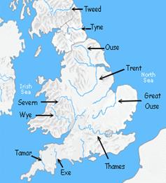
Being a relatively small Island, the UK's rivers are not very long. The longest river in the UK is the river Severn, just 220 miles in length. It begins in Wales and enters the Atlantic Ocean near Bristol in England. Among the most important rivers in the UK is the Thames, which flows through Oxford and London and into the North Sea. Its length is 346 km and it is the deepest river in Britain. It is navigable as far as the capital of Great Britain – London.
Other major rivers include the Trent and Mersey rivers, which drain rainfall from large areas of central England. Some of the British greatest ports are situated in the estuaries of the Thames, Mersey, Trent, T Clyde and Bristol Avon.
Demography of the United Kingdom: According to the 2011 census, the total population of the United Kingdom is around 63,100,000 the third-largest in the European Union (behind Germany and metropolitan France) and the 22nd-largest in the world. Its overall population density is one of the highest in the world at 660 people per square mile, due to the particularly high population density in England (currently over 1000 people per square mile).
Almost one-third of the population lives in England's southeast and is predominantly urban and suburban, with about 7.8 million in the capital city of London, the population density of which is just under 13,000 per square mile. Population estimates by UK National Statistics:
| Part | Population (2010) | Percentage (2010) | |
| England | 51,809,700 | 83.8 | |
| Scotland | 5,222,100 | 8.4 | |
| Wales | 3,006,400 | 4.8 | |
| Northern Ireland | 1,789,000 | 3.0 | |
| United Kingdom | 61,827,200 |
| United Kingdom | Population at start of period | Overall annual change | Births | Deaths | Natural change | Net migration and other changes |
| 1901 – 1911 | 38,237 | 1,091 | -82 | |||
| 1911 – 1921 | 42,082 | -92 | ||||
| 1921 – 1931 | 44,027 | -67 | ||||
| 1931 – 1951 | 46,038 | |||||
| 1951 – 1961 | 50,225 | |||||
| 1961 – 1971 | 52,807 | -12 | ||||
| 1971 – 1981 | 55,928 | -27 | ||||
| 1981 – 1991 | 56,357 | |||||
| 1991 – 2001 | 57,439 | |||||
| 2001 – 2008 | 59,113 |
Population levels at census dates and average adjustments annually (thousands)
| Ethnic group | Population | % of total* |
| White British | 50,366,497 | 85.67% |
| White (other) | 3,096,169 | 5.27% |
| Indian | 1,053,411 | 1.8% |
| Pakistani | 977,285 | 1.6% |
| White Irish | 691,232 | 1.2% |
| Mixed race | 677,117 | 1.2% |
| Black Caribbean | 565,876 | 1.0% |
| Black African | 485,277 | 0.8% |
| Bangladeshi | 283,063 | 0.5% |
| Other Asian (non-Chinese) | 247,644 | 0.4% |
| Chinese | 247,403 | 0.4% |
| Other | 230,615 | 0.4% |
| Black (others) | 97,585 | 0.2% |
| * Percentage of total UK population |
From the United Kingdom Census 2001:
• The UK population is projected to increase by 4.9 million from an estimated 62.3 million in 2010 to 67.2 million over the ten year period to 2020
• Projected natural increase (more births than deaths) accounts for 56 per cent of the projected increase over the next decade
• The UK population is projected to increase to 73.2 million over the 25 year period to mid-2035, which is equivalent to an average annual growth rate of 0.6 per cent
• The UK population is projected to reach 70 million by mid-2027
• The population is projected to continue ageing with the average (median) age rising from 39.7 years in 2010 to 39.9 years in 2020 and 42.2 by 2035
Cities of Great Britain: About a nine tenth of the English people live in cities and towns. About 40% of the urban residents live in England's seven metropolitan areas. Greater London, the largest metropolitan area, has about 7 million people, which is over 10% of Great Britain's total population.
Interesting to know: Greater London is the top-level administrative subdivision covering London England. The administrative area was officially created in 1965 and covers the City of London (including Middle Temple and Inner Temple), the City of Westminster and the other 31 London boroughs. Its area also forms the London region of England and the London European Parliament constituency. It covers 1579 km² (609 square miles) and had a 2006 mid-year estimated population of 7,512,400.
The six other metropolitan areas are: Greater Manchester (Manchester is the largest city of the area), Merseyside (Liverpool), South Yorkshire (Sheffield), Tyne and Wear (Sunderland), West Midlands (Birmingham), and West Yorkshire (Leeds).

Manchester is one of Great Britain's chief centers of trade and finance. Its port handles about 14 million short tons of cargo annually. The city has many banks and insurance companies and a stock exchange. Manchester and its surrounding communities also rank as one of Britain's leading manufacturing areas. Products include chemicals, clothing and textiles, computers, electronic equipment, industrial machinery and machine tools, paper, precision instruments, and processed food.
Liverpool is a large commercial and manufacturing city. The commercial center of Liverpool is one of the largest shopping districts in Great Britain. Liverpool was founded in 1207 and began to flourish as a trade center in the 1700's. At the same time, it became an important port city. Shipping remains as important economic activity in the Liverpool area today. Major industrial facilities of the city include flour mills, sugar refineries and an automobile manufacturing plant. During World War II, German bombers heavily damaged the city and its docks. Since the war the decline of the port, plus other factors, have contributed to a high rate of unemployment in the city.
An important manufacturing city, Sheffield has long been a center for the production of high - grade steel, silver plate, and metal products. Its cutting tools and «cutlery» - silver ware, teapots, and other table utensils - are internationally famous.
Birmingham is the second largest city in Great Britain. Only London has more people. Birmingham's factories manufacture a wide variety of products. The chief items include automobiles, computers, electronic circuits, machine tools, and wire. Anglican settlers founded Birmingham, probably in the A. D. 600's. The city became a trading center during the 1100's, and industries began to develop there in the 1500's. Birmingham grew into an industrial city because of nearby coal and iron ore deposits, and other important natural resources. Today, Birmingham and the surrounding communities form Britain's chief manufacturing area.
Leeds is the center of the clothing industry of West Yorkshire in England. It is also an important producer of wool textiles. The important Yorkshire coal field lies to the south and south east of Leeds. The field provides coal for several power stations in the region. Clothing and wool textiles are the traditional products made in Leeds. In addition, Leeds has developed important computer, defense, electronic, engineering, and vehicle industries. The city is a major cultural and business center and the home of the University of Leeds.
Glasgow is the largest city in Scotland and a center of industry and commerce. It lies on both sides of the River Clyde which leads into the Atlantic Ocean near Glasgow, and the city serves as a port for oceangoing vessels. Glasgow is a center of engineering activities. Its manufactured goods include computers and other electronic products. Major Scotch whisky firms have their headquarters in the city. Glasgow is a center for Scottish television broadcasting, and some filmmaking takes place there. James Watts developed his steam engine near Glasgow.
Environment issues
1. Climate: The United Kingdom straddles the geographic mid-latitudes between 50-60 N from the equator. It is also positioned on the western seaboard of Eurasia, the world's largest land mass. These boundary conditions allow convergence between moist maritime air and dry continental air. In this area, the large temperature variation creates atmospheric instability and this is a major factor that influences the often unsettled weather the country experiences, where many types of weather can be experienced in a single day. 
Regional climates in the United Kingdom are influenced by the Atlantic Ocean and latitude. Northern Ireland, Wales and western parts of England and Scotland, being closest to the Atlantic, are generally the mildest, wettest and windiest regions of the UK, and temperature ranges here are seldom extreme. Eastern areas are drier, cooler, less windy and also experience the greatest daily and seasonal temperature variations. Northern areas are generally cooler, wetter and have a slight bigger temperature range than southern areas. Though the UK is mostly under the influence of the maritime tropical air mass from the south-west, different regions are more susceptible than others when different air masses affect the country: Northern Ireland and the west of Scotland are the most exposed to the maritime polar air mass which brings cool moist air; the east of Scotland and north-east England are more exposed to the continental polar air mass which brings cold dry air; the south and south-east of England are more exposed to the continental tropical air mass which brings warm dry air (and consequently most of the time the warmest summer temperatures); Wales and the south-west of England are the most exposed to the maritime tropical air mass which brings warm moist air. If the air masses are strong enough in their respective areas during the summer there can sometimes be a massive difference in temperature between the far north/north-west of Scotland (including the Islands) and south-east of England - usually around 10-15°C (18-27°F) but can be as much as 20°C (36°F) or more. An example of this could be that in the height of summer the Northern Isles could be sitting at around 15°C (59°F) and areas around London could be basking at 30°C (86°F).
2. Biodiversity: In most of Great Britain there is a temperate climate which receives high levels of precipitation and medium levels of sunlight. Further northwards, the climate becomes colder and coniferous forests appear replacing the largely deciduous forests of the south. There are a few variations in the generally temperate British climate, with some areas of subarctic conditions in areas such as the Scottish Highlands and Teesdale, and even subtropical in the Isles of Scilly. The seasonal changes that occur across the archipelago mean that plants and animals have to cope with many changes linked to levels of sunlight, rainfall and temperature, as well as the risk of snow and frost during the winter.