Unit II. Depressions
Depression – центр низкого давления
Occlusion – окклюзия
Intermittent– прерывистый
Persistent– устойчивый, постоянный
Disturbance – возмущение, волнение
Incursion– наступление, вторжение
Poleward – по направлению к полюсу
Slope –понижение температуры от экватора к полюсам
Discontinuity– разрыв, перерыв
Surface boundary – поверхностная граница
Weather sequence – метео ряд наблюдений
Bank of clouds –гряда облаков
Cirrus– перистые облака
Cumulus– кучевое облако
To decay - спадать, затухать
To trail – идти сзади
To occlude – преграждать, закупоривать
Overcast – покрытый облаками, пасмурный
To obscure – затемнять, затмевать
To veer– менять направление по часовой стрелке (в северном полушарии и против часовой стрелки в южном полушарии)
To back – менять направление против часовой стрелки
To ease – ослабевать
To recede – отступать
To ascend– подниматься
To moderate –стихать, становиться умеренным
To overtake – догнать, обрушиваться, овладевать
To override– замещать, вытеснять (о фронтах)
Exercise 1. First read the text quickly. Write down one thing about each phenomenon that you can remember. Share what you have written with other students in the class.
Exercise 2. Read the text again. Match the following English words with their Russian equivalents.
| 1.circular shape | 1. штормовой ветер |
| 2. unsettled weather conditions | 2. система умеренных широт |
| 3.gale force wind | 3. повышение давления |
| 4.middle latitude system | 4. неустойчивые погодные условия |
| 5.filling | 5. различные воздушные массы |
| 6.boundary zone | 6. фронтальная прерывистость |
| 7.contrasting air masses | 7. округлая форма |
| 8. frontal discontinuity | 8. пограничная зона |
| 9. showery conditions | 9. условия ливневых осадков |
10. trail 10. преграждать
11. cirrus 11. идти сзади
12. slope 12. затухать
13. occlude 13. постоянный
14. decay 14. понижение температуры
15. persistent 15. перистые облака
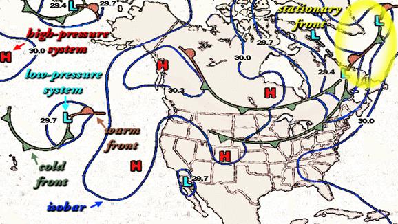
Look at the chart 1. Pay attention to the charted symbols and abbreviations.
Depressions
Description
A depression (or Low) appears on a meteorological chart as a series of isobars roughly circular or oval in shape around the center where pressure is lowest. Depressions are frequent in middle latitudes and give unsettled weather conditions; they are very often, though not always, accompanied by strong winds. They vary greatly in size from very small features to very large circulations over 2000 miles in diameter; central pressure in extreme cases may be as low as 950 mb/h Pa. The extent and power of a deep and large depression cannot only produce gale force winds but raise very high, persistent and dangerous sea. In the N hemisphere the wind circulation around a depression is anticlockwise and slightly inwards across the isobars towards the low pressure; in the S hemisphere the circulation is clockwise.
Depression may move in any direction though most middle latitude systems move in a generally E direction. There is no normal speed movement. A small developing and perhaps very attractive depression can travel very quickly indeed, possibly 30—60 Kn.; but as a depression deepens into a large system it usually moves much more slowly and especially so when decaying and filling.
Fronts
Depressions often originate on a front which is the boundary zone between two contrasting air masses. In middle latitudes it is usual for air moving from the Polar Regions to encounter warm air from the subtropics moving in the opposite direction. At the frontal boundary where the two meet there is a tendency for small disturbances to develop on the front where the warm air makes incursions into the cold air mass and in vice versa; the warm air rises over the cold air.
Warm front
When the air in the warm sector of the depression meets the denser cold air on the frontal boundary, the warm air overrides it; extensive cloud and precipitation covering a wide area result as the warm air ascends.
Cold front
The cold air behind the front overtakes the warm air of the warm sector and undercuts it, causing the less dense warm air to rise; often quite suddenly so that a belt of large cumulus or cumulonimbus cloud results.
Occlusion
In a frontal system the cold front generally moves faster than the warm front and eventually overtakes it, thereby closing or occluding the warm sector of the depression. Thereafter the warm front may displace the warm front effectively leaving a surface cold front with mixed characteristics of both warm and cold fronts: a "cold occlusion". Alternatively when the air behind the cold front is less dense than the air ahead of the warm front, the cold front will rise up the warm frontal discontinuity effectively leaving only a warm front at the surface but again with mixed characteristics of both warm and cold fronts: a "warm occlusion”.
In both cases the air in the warm sector is lifted from the surface and the depression subsequently becomes less active and starts to fill.
Weather
The approach of a depression is indicated by a falling barometer. If a depression is approaching from the W and passing on the poleward side of the observer high cirrus clouds appear in the W and the wind shifts to the SW or S in the N hemisphere or to the NW or N in the S hemisphere. The cloud layer increases to give overcast skies which gradually obscure the sun; as the cloud becomes progressively lower rain, or snow, at first intermittent, becomes continuous and heavier. As the warm front passes, the wind veers in the N hemisphere, or backs in the S hemisphere, the fall of the barometer eases and the temperature rises as the rain stops or moderates.
The arrival of the cold front is marked by the approach from the W of a thick bank of cloud as the front passes, a further veer of the wind to W or NW in the N hemisphere, or backing to W or SW in the S hemisphere, may be accompanied by a squall. A belt of heavy rain, hail or snow precedes the arrival of cooler, clearer air as the barometer begins to rise. As the depression recedes, showery conditions may develop; a second cold front similar in character to the first one sometimes marks the arrival of yet colder air. When the depression is occluded the weather sequence ahead of the front is similar to the approach of a warm front; but as the front passes, a short period of heavy rain may occur as the cold air behind the front arrives, and the wind veers in the N hemisphere, or backs in the S hemisphere.
Exercise 3. How do you understand the following word combinations? Explain them in English.
In extreme cases; A deep and large depression; Persistent and dangerous sea; An attractive depression; To originate; Contrasting air masses; Extensive cloud; To undercut the warm air sector; To have mixed characteristics; Subsequently.
Exercise 4. Find the English equivalents to the following word combinations in the text.
Метеорологическая карта; система изобар; овальная форма; создавать неустойчивые погодные условия; в крайних случаях; обычная скорость движения; углубляться в систему; сталкиваться с теплым воздухом; небольшое волнение; вторгаться в холодные воздушные массы; широкий пояс дождевокучевых облаков; преграждать теплый сектор депрессии; впоследствии; в ином случае; подниматься с поверхности; последовательно; начинать повышаться (о давлении); пасмурное небо; закрывать солнце постепенно; умеренный дождь; обширная гряда облаков; сопровождаться порывистым ветром с дождем и снегом; ряд метео наблюдений; ветер дует против часовой стрелки.
Exercise 5. Discuss the main problems using the following questions.
1. What is depression? Where can it occur?
2. Does depression vary in size?
3. What is wind circulation around depression in the N hemisphere?
4. What is wind circulation around depression in the S hemisphere?
5. What direction does depression move mainly?
6. What is the speed of depression?
7. Where does depression originate?
8. What is the warm front?
9. What is the cold front?
10. What is the occlusion?
11. Is it possible to indicate the approach of depression?
12. How do the weather conditions change if depression approaches from the W?
13. How do the weather conditions change if depression recedes?
14. How do the weather conditions change if depression is occluded?
Exercise 6. Read the text again. Underline and correct the wrong information if necessary.
· Depressions are rare in middle latitudes and give rather settled weather conditions.
· In the S hemisphere the wind circulation around a depression is anticlockwise.
· Depressions move only in E direction.
· A small developing depression travels very quickly.
· The cold air rises over the warm air.
· Cumulonimbus cloud is the first sign of the approaching warm front.
· In a frontal system the cold front generally moves slower than the warm front.
· In both cases of a "cold occlusion" and "warm occlusion" the air in the warm sector is lifted from the surface and the depression becomes less active.
· As the warm front passes, the wind backs in the N hemisphere, and the temperature falls as the rain stops.
· The arrival of the cold front is marked by the approach from the W of a thick bank of cloud.
· A belt of heavy rain or snow precedes the arrival of warmer air, as the barometer begins to fall.
Exercise 7. Complete the charts with the different parts of speech. The missing words are all from the above text.
| Verb | Noun | Verb | Noun |
| appearance | indicator | ||
| shape | increase | ||
| circulate | moderation | ||
| production | recession | ||
| direct | occurrence | ||
| depth | arrival | ||
| decay | observe | ||
| origin | approach | ||
| tend | lay | ||
| disturb | mark | ||
| ascent | result | ||
| precedence | tail | ||
| warn | |||
| circle | persistence | ||
| frequency | extension | ||
| strength | density | ||
| extremity | activity |
Exercise 8. Give three forms of the verbs (if they have) with a translation.
To override, to veer, to overcast, to back, to ascend, to overtake, to trail, to undercut, to rise, to obscure, to recede, to ease, to become, to moderate, to begin, to appear.
Exercise 9. Put the words in the right order and translate the sentences.
· depth, in, vary, Depressions, much, size, and.
· Depression, knots, as, may, fast, move, as, 60.
· last, Lows, normally, around, days, 4, to, 6, and, filling, down, slow, when.
· A, a, barometer, the, indicates, of, approach, depression, falling.
· are, in, Depressions, at, frequent, latitudes, sea, middle.
· are, most, Lows, responsible, unsettled, for, weather.
· are, all, strong, depressions, accompanied, by, Not, winds.
· One, depression, only, be, in, may, 100, over, miles, diameter, and, another, 2,000.
Exercise 10. Put the verbs in brackets in the correct tense form. Translate them.
A depression … (to appear) on a synoptic chart as a series of isobars roughly circular or oval in shape, surrounding an area of low pressure.
Oceanic depressions … (to have usually) one or more fronts extending from their centres.
These … (to be) intense depressions occurring in tropical latitudes accompanied by high winds and heavy seas.
If the wedge… (to move) into an area of warmer air, the front … (to be called) a cold front.
If the wedge … (to retreat) and warmer air … (to move) into an area previously occupied by cool air, the front … (to be termed) a warm front.
Cold fronts … (bring usually) cooler weather, clearing skies, and a sharp change in wind direction.
Because cold fronts … (to move) faster than warm fronts, they… (can, to catch up to) and … (to overtake) their related warm front. When they … (to do), an occluded front … (to be formed).
In the rain area there… (to be) often a long period of continuous rain and unpleasant weather with low cloud.
If the depression … (to be not occluded), after a period of continuous rain or snow there … (to be) a veer (backing) of the wind at the warm front.
In the N hemisphere, if a depression … (to approach) from the W and … (to pass) to the N of the ship, clouds … (to appear) on the W horizon, the wind … (to shift) to a SW or S direction and … (to freshen), the cloud layer gradually … (to lower) and finally drizzle, rain or snow … (to begin).
Exercise 11. Rewrite the sentences using the word in italics in a different word class.
Ex. Depressions may move in any direction.
The movement of depressions may be in any direction.
A depression appears on a meteorological chart as a series of isobars.
Depressions may be very large circulations over 2000 miles in diameter.
Middle latitude systems move in a generally E direction.
The decay of a depression results in slow movement.
Depressions originate on a front.
Extensive cloud and precipitation result as the warm air ascends.
The "tail" of a cold front is the place of origin for further wave depressions.
The air behind the cold front may be less dense than the air ahead of the warm front.
Exercise 12. Match the following abbreviations from English Meteocharts. Translate them.
CLD, G\GW, DNS, TD, OCLN, FNT, SHWR, R, MPH, SQLL, TMP, VSBY, M.
Exercise 13. Each student writes any sentence about depressions on a sheet of paper and passes his paper to the student on his left. The second student reads and checks the sentence (sentences) and adds a new one then passes the paper on. When you get your paper back, check and rearrange the sentences to get a logical text. If necessary add link words and/or more sentences. Swap your text with a partner to check the output.
Unit III. Tropical storms. Fog. Cloudiness.
Revolving storm – вращающийся шторм
Confused sea – нерегулярное волнение на море (9 баллов)
High sea – сильное волнение (6 баллов)
Restricted water – стесненные воды
Violent – сильный, интенсивный
Adequate – соответствующий
Well-found – хорошо подготовленный
Erratic– неустойчивый
Precursory – предвещающий
To recur – повторяться, происходить вновь
To preclude – предотвращать
To enhance – увеличивать, усиливать
To dissipate– рассеиваться
To recurve – загибаться назад, в обратном направлении
Eye – "Глаз бури"
Thick weather – туманная погода с плохой видимостью
Dew point – точка росы, точка таяния
Advection fog – адвективный туман
Minute– мелкий, мельчайший
Altostratus– высокослоистые облака
Scud– разорванно-слоистые облака
Stratus – слоистые облака
Cirrostratus – перисто-слоистые облака
Cirrocumulus – перисто-кучевые облака
Altocumulus – высококучевые облака
Nimbostratus – слоисто-дождевые облака
Stratocumulus – слоисто-кучевые облака
Cumulonimbus – кучево-дождевые облака
Exercise 1. Check your ideas with the text and discuss the problems.
1. Where do tropical storms develop?
2. When danger of tropical storms is especially enhanced?
3. What weather do anticyclones give?
4. What is fog caused by?
5. What is the main type of fog experienced at sea?
6. Where does "frost smoke" occur?
7. What is the cause of frontal fog?
8. Why is radiation fog found not far from the shore?
Tropical storms. Fog. Cloudiness
Tropical storms
Tropical storms are intense depressions which develop in tropical latitudes; they are often the cause of very high winds and heavy seas. Although the pressure at the center of a tropical storm is comparable to that of an intense middle latitude depression, the diameter of a tropical storm is much smaller (typically some 500 miles compared with 1500 miles) and thus the related pressure gradients and the wind speed are correspondingly greater. The wind blows around the center of a tropical storm in a spiral flow inwards, anticlockwise in the N hemisphere and clockwise in the S hemisphere: hence the occasional alternative name "revolving storm". Within the circulation of a tropical storm the wind is often very violent and the seas are high and confused; considerable damage may be done even to large and well-found ships. The danger is especially enhanced when ships are caught in restricted waters without adequate room to maneuver and early action may be essential to preclude such a situation arising.
Tracks followed are very variable in, all areas and individual tracks may be quite erratic. When a storm moves inland it weakens and eventually dissipates; but if it should reemerge to follow an Ocean track again it may reintensify. The speed of storms is usually about 10 kn in their early stages increasing slightly with latitude but seldom exceeding 15 kn before recurring. A speed of 20—25 kn is usual after recurring though speeds of over 40 kn have been recorded. Radar may give warning of a storm within about 100 miles.
Anticyclones
Over the E sides of the oceans the movement of anticyclones (or Highs) is generally slow and erratic and they may remain stationary for several days giving settled weather. The pressure gradient is usually slight, the winds light to moderate and the weather are often or partly cloudy; but in winter and in temperate latitudes skies may become overcast to give gloomy conditions. Precipitation, even a drizzle, is uncommon near the middle of an anticyclone. Over the W parts of the oceans anticyclones are more likely to move quickly and consequently, the associated weather is more changeable. Movement is generally towards the E.
Fog is a cloud that touches the ground. Dense fog will reduce visibility considerably and is referred to as "thick weather". Fog is caused by the cooling of air to a temperature (known as the "dew point") at which it becomes saturated by the water vapour which is present within it. Condensation of the water vapour into minute water droplets produces fog; the type of fog depends on the means by which the air is cooled.
Sea or advection fog
When warm moist air flows over a relatively cold sea surface which cools it below its dew point, sea or advection fog is formed. This is the main type of fog experienced at sea; it may form and persist with moderate or even strong winds. It is often shallow so that mastheads of ship may protrude above it; and at times its base is a few feet above sea level with a clear layer below the fog.
Frontal fog
On a warm front or occlusion fog may occur especially if the temperature of the air in advance of the front in very low. The fog is due to the mixing of the warm and cold air on the two sides of the front.
Arctic sea smoke
Also known as "frost smoke", arctic sea smoke occurs chiefly in high latitudes and is produced when very cold air blows over a relatively warm sea surface.
Radiation fog
Over low-lying land on clear nights (conditions for maximum radiation), radiation fog forms, especially during winter months. Occasionally it drifts out to sea but is found no further than 10—15 miles offshore as the sea surface temperature is relatively high which causes the water droplets to evaporate.
Cloudiness
Clouds are continually changing and appear in a variety of forms. It is possible however to define a limited number of characteristic forms, observed all over world, into which clouds can be broadly grouped.
| Level | Designation | Type | Abbreviation | ||
| High (base usually > 20 000 ft) | C | CH | Cirrus Cirrocumulus Cirrostratus | Ci Cc Cs | |
| Medium | C | Altocumulus | Ac | ||
| (base usually > 6 500 | CM | Altostratus | As | ||
| and < 20 000 ft) | Nimbostratus | Ns | |||
| c | Stratocumulus | Sc | |||
| Low | CL | Status | St | ||
| (base usually < 6 500 ft) | Cumulus Cumulonimbus | Cu Cb |
Exercise 2. Find the English equivalents to the following word combinations in the text.
Глубокая депрессия; сильный ветер; глубокая депрессия средних широт; спиралевидный поток; отсюда (следовательно); значительное повреждение; хорошо-оборудованное судно; соответствующее пространство; появляться заново (на поверхности); усиливаться снова; устойчивая погода; переменная облачность; умеренные широты; пасмурные погодные условия; мелкие водяные капли; теплый влажный воздух; относительно холодная поверхность моря; выступать (выдаваться над поверхностью); арктический туман под полыньей; низина; обозначение (в таблице).
Exercise 3. Match the following verbs with their synonyms.
| 1. recur | 1. strengthen again |
| 2. dissipate | 2. overhang |
| 3. reemerge | 3. come again |
| 4. produce | 4. clear out |
| 5. occur | 5. cause |
| 6. enhance | 6.arise again |
| 7. protrude | 7. happen |
| 8. reintensify | 8. increase |
Exercise 4. Jumbled words. Rearrange the letters to make and match them with their definitions.
| 1.uirscr | 1. This middle cloud is composed of water droplets, and sometimes ice crystals. White to gray in color, it can sometimes obscure the sun or the moon. It is a good indicator of precipitation, as it often precedes a storm system. Virga often falls from these clouds. |
| 2. oltaatrssut | 2. This cloud is characterized by thin, wispy strands. It generally appears white or light grey in color. |
| 3. obminstuatrs | 3. This cloud is also called a thunderstorm cloud, it is frequently accompanied by heavy showers, lightning, thunder, and sometimes hail, tornadoes or strong, gusty winds. |
| 4. sumoluinbmuc | 4. This cloud is characterized by a formless cloud layer which exhibits a combination of rain or snow. |
Exercise 5. Find in the text the terms which mean.
· An organized low pressure system in the tropics with wind speeds between 38 and 74 mph.
· A large body of air in which the atmospheric pressure is higher than the pressure in the surrounding air. The winds blow clockwise around an anticyclone in the Northern Hemisphere.
· It is formed over the ocean as a result of processes when air over a warm water surface is transported over a colder water surface, resulting in a cooling of the lower layer of air below its dew point.
· The temperature to which the air must be cooled for water vapor to condense and form fog or clouds.
· Evaporation (steam) fog produced above a surface of open water within Arctic ice when the air is stable and relatively cold.
Exercise 6. Are the following statements true or false? Correct the false ones.
· The diameter of a tropical storm is 1500 miles.
· The danger of tropical storms decreases when ships are caught in restricted waters.
· Individual tracks of tropical storms may be quite erratic.
· Radar may give warning of a storm within about 100 miles.
· Anticyclones remain stationary for several hours giving settled weather.
· Drizzle is common near the middle of an anticyclone.
· Sea fog is often shallow.
· Frontal fog is due to the mixing of the warm and cold air on the two sides of the front.
· Radiation fog forms especially during summer months.
· Clouds have an unlimited number of characteristic forms.
Exercise 7. What do these numbers in the text refer to?
500 miles, 10 kn-15kn, 10—15 miles, < 6 500 ft, < 20 000 ft, > 20 000 ft, 100 miles, 20—25 kn, 40kn.
Exercise 8. Here are some answers. Compose the questions.
1. What___________________alternative__________? "Revolving storm".
2. What ________________________? About 10 kn.
3. What ________________________? "Thick weather".
4. What ________________________? Condensation of water vapours into minute water droplets.
5. What distance _________________? 10—15 miles offshore.
6. Where____”frost smoke”_________? In high latitudes.
7. What direction _________________? Anticlockwise in the N hemisphere.
8. What_______________________? Frontal fog.
9. What ______________________? Ns.
Exercise 9. Read the texts below and translate the words in italics into English.
A. Тропические шторма develop only over океанами, and origination is especially frequent near the seasonal location of the Экваториальной Депрессии. In the северном полушарии storms form mostly in the поясе 5°—15°N early and late in сезон штормов, and between 10°N at the height of the seasons; in the Североатлантическом океане storm formation between 25°N and 30°N is fairly common. In the южном полушарии most storms develop between 5°S and 18°S. Those which влияют the W Pacific, S Indian and N Atlantic Oceans are usually first reported in the восточной части of these Oceans; there are исключения such as in the N Atlantic Ocean during августа and September when an occasional storm возникает near Archipelago old Cabot Verde.
B. SOLAS 1974 утверждает that when a ship suspects the existence of or is in поблизости a tropical storm капитан must передать информацию by all means в его распоряжении to ships in the vicinity and to the nearest береговую радиостанцию or сигнальный пост with which he can communicate. A report is similarly required if a ship should encounter winds of force 10 or свыше of which никаких предупреждений has been received.
C. Штормовое предупреждение of the position, интенсивности and предполагаемом передвижении of each storms are broadcast на частоте and с равными интервалами. The following terms are общеприняты to describe tropical circulations at various стадиях of intensity:
Tropical Depression Сила ветра 7 or меньше
Tropical Storm Сила ветра 8 and 9
Сильный Tropical Storm Сила ветра 10 and 11
Exercise 10. Say the following sentences in English.
1 Перисто-слоистые и перисто-кучевые облака состоят из ледяных кристаллов. 2 В мире ежегодно наблюдается около 80 тропических циклонов. 3 Облака возникают в результате конденсации водяного пара, содержащегося в воздухе. 4 В северном полушарии воздух в антициклоне движется по часовой стрелке, в южном полушарии - против часовой стрелки. 5. Туман - это атмосферное явление, которое означает скопление в воздухе мельчайших продуктов конденсации водяного пара. 6. Адвективные туманы образуются вследствие охлаждения тёплого влажного воздуха при его движении над более холодной поверхностью суши или воды. 7. Для антициклона характерно преобладание ясной или малооблачной погоды. 8. Обычно радиационный туман возникает ночью в условиях антициклона при безоблачной погоде и лёгком бризе. 9. Ураган Катрина, который полностью затопил и разрушил Новый Орлеан, был самым мощным и опасным тропическим штормом в истории Америки. 10. Фронтальные туманы образуются вблизи атмосферных фронтов и перемещаются вместе с ними.
Exercise 11. Match the following abbreviations from the English Meteocharts. Translate them.
| 1.DWPNT | 1. Condition | 1. Точка росы |
| 2. FLG | 2. Tropical storm | 2. Безоблачное небо |
| 3.SKC | 3. Fog | 3.Штормовой ветер |
| 4. F | 4.Sky clear | 4.Тропический шторм |
| 5.TS | 5. Dew point | 5. Условие |
| 6. CND | 6. Falling | 6. Туман |
| 7.SW | 7. Knots | 7. Узлы |
| 8. KTS | 8. Stormy wind | 8. Понижение |
| 9. L | 9. Centre | 9. Циклон |
| 10.CNTR | 10.Low | 10. Центр, центральный |
Exercise 12. Give the abbreviations to the following words from the English Meteocharts.
Increase, millibars, partly, Northern hemisphere, typhoon, snow, during, little, around, till, period, movement, forming, in vicinity, higher, across, decreasing, interrupted, likely, mile, surface, station, toward, wide, outlook, region, slit.
Exercise 13. Give the summary of the text “Tropical storms. Fog. Cloudiness”, using the following expressions:
The text is headlined….It is about…..
The text deals with…..
The aim of the text is to provide some information on….
The text describes…..Further it is said that….
In conclusion…