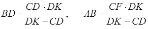
Beruniy created a simple and very easy way of measuring the distances on the surface of the Earth in his book “Geodesy” (Al-Beruniy, Geodesy, “Fan”, 1982, p. 167).
For this he took  square with the sides equal to 1, knocking nails into the points
  and
and  , established long diopterical level to the point
  (Figure 4).
Figure 4
It is necessary to establish the square to the point in such a way so that the points  lay on one straight line. Then we drop a stone from the point (with the Beruniy’s words) and draw perpendicular
  .
.
From
 ,
, 
we shall obtain the equalities
 ,
,  . (1)
. (1)
Measuring of the Earth
The 1st attempt to measure the diameter of the Globe is connected with the name of Eratosfenes (276-196 BC). He determined the measurements of the Globe according to the position of the Sun in Aswan and Alexandria. According to his determination, when in Egypt the Sun is at Zenith, in Alexandria it reaches 7,20 in relation to Zenith and from this, having specified, that on the globe the arch connecting Aswan and Alexandria, reaches 7,20, determines its conformity to 1/50 part of the large circumference of the Globe.
So he multiplied the distance between Aswan and Alexandria by 50 and calculated the length of the Earth’s large circumference. Ptolemy (II CE) also tried to calculate the measurements of the Globe and he expressed his ideas about the parameters of the Earth in his book “Geography”. But the scholars of the ancient times used “Stadiy” as a unit of measurement and as time passed by, especially during the academy “Bait ul-Hikma’s” period (IX century), it turned out that due to the vagueness and contradictions among the units of measurement, there were many mistakes in the values of the Earth’s measurements.
Therefore, the chalif al-Mamun ibn ar-Rashid charged the scholars of the academy “Bait ul-Hikma” with the task of determining the real measurements of the Globe. Observations were carried out in the Sinjor desert near Mosul and mostly the Middle Asian scholars took part in this investigation work. Under the leadership of our countryman al-Khorezmiy, the scholars of “Bait ul-Hikma” fulfilled the task successfully.
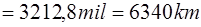
They determined that the radius of the Earth was equal to  or 6406 km*), but in fact the actual radius of the Earth at the equator is equal to
  km and the Polar circle is equal to 6357 km.
Describing in details the attempts of his forerunners in measuring the size of the Earth in his books “Geodesy”, “Konuniy Masudiy” Abu Raihon Beruniy (973-1048) offered another new method. Beruniy wrote: “Only Greek and Indian versions of measurement of the Earth came up to us. Greek’s and Indian’s units of measurement were different, for example one mil which Indians used to measure the circumference of the Earth was equal to between one and eight our miles and the various measurements confused their thoughts for various scholars had different results. In each of their five “Siddihonta”s the value of the Earth circumference was different. But Greeks measured the circle of the Earth by one quantity, which was called “ stadiya ”. According to Galen, Eratosthenes carried out observations in Aswan and Alexandria, which are situated on the same meridian.
Whenever the words in Galen’s book “The Book of Provements” are combined with the words from Ptolemy’s book “Entering the Art of Sphere” again the quantity will be different. Therefore, Mamun ibn ar-Rashid charged the leaders of the science, who carried out the investigation in the Sinjor desert of Mosul to pay attention to such contradictions.
If any man moves along a straight line on the Earth plane, he will move along the big circle of the Earth. But it is difficult to pass far distance along the straight line. That’s why the scientists of the Mamun Academy took the pole of the Earth as a reference point (the pole-star seems to be meant here). Being careful, they determined that one part of circle in 3600 was equal to  miles.
“I myself was eager to measure the Earth and I chose a large plane land in Jurjon. But because of the inconvenient condition of the desert, the absence of the people, who could help me out, I found a high mountain with a smooth surface in the lands of India and used a different way of measuring it. From the top of the mountain I found the horizon of the Sky and Earth (Figure 5) and calculated its angle, which was equal to  , measured the top of the mountain in two places and it was equal to 652 gaz, and calculated a half of a one-tenth of a gaz.
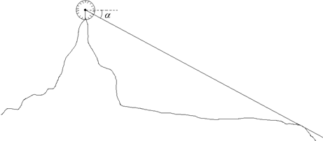
Figure 5
Let the line  which is perpendicular to the sphere of the Earth be the height of the mountain (Figure 6).
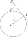
Figure 6
The centre of the Earth is  , the line originating on the top of the mountain and going towards the horizon is
  , and we shall draw
  perpendicular to the horizon line. Consequently, we get triangle
  .
.
Its angle  is a right angle and all other angles are known. Because the angle
  is the supplement angle of the horizon slope angle, that is,
  …” (al-Beruniy, Konuniy Masudiy, book - 5, 1973, p.p. 386-387).
So according to the definition of sine, the radius of the Earth  is calculated. From
  we get
  , from this
 Or
Or 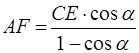 (2)
(2)
Knowing the height of the mountain and the value of sin  Beruniy established, that the radius of the Earth is
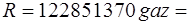
 .
.
In his book “Geodesy” Beruniy also wrote that, during Chaliph al-Mamun’s marching to Greece (830-832) he asked the mathematic scholar Abu Taiyib Sanad ibn Aly who also was with him, to ascend a mountain which stuck out of the East side of the Sea and from its top to determine the lower angle (for accuracy, during the sunset), and that when he fulfilled the task, they calculated the radius of the Earth using the lower angle and some additional angles (al-Beruniy, “Geodesy”, “Fan”, 1982, p. 166).